Several parts of the State have unusually high fire danger and also a high risk of a bushfire starting, due to natural factors such as lightning, or human carelessness. They are areas where there is a patchwork pattern of land tenure, with a mixture of forested land, hobby farms, “lifestyle” peri-urban developments and farmland. Sometimes, as on the Leeuwin-Naturaliste Ridge, the is the further complication of absentee landowners, which means that some blocks of land have no one living on them to take prompt action in case of a bushfire.
These two areas, the Perth Hills, covering the area from about Gidgegannup in the north to Jarrahdale in the south, and the Leeuwin-Naturaliste Ridge are examples of regions requiring extra effort to maintain low fuel loads.
Overgrown Roads
A short drive around the Hills area will show that there are many places that would be very dangerous in a severe wildfire. Quite apart from the heavy fuel loads on many private property blocks and on the scattered blocks of forest that constitute the Darling Range Regional Park (which would support a Victorian style disaster), there are many examples of overgrown roads that would make escape from a bushfire almost impossible.
Here is just one example, below. It was Moola Road, Glen Forrest a few years ago (it has had a fuel reduction burn since then). You can see how heavy shrubbery grows right up to the road surface, almost touching the sides of a vehicle at one point. If this was on fire, a vehicle could not escape the flames. This was a crucial issue in the 2009 Victorian fires.
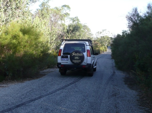
The bush either side of this spot had not been burned for over 10 years. Who is responsible for maintaining the road verges in a state that would allow vehicles to escape in the event of a severe wildfire? Just now this is a death trap situation. It cannot be allowed to remain that way.
And there is another thing. There is a powerline situated down the right hand side of this same road in the photo. At the very least, the poles will burn down, but the wires might also be melted. Not cheap to replace, not to mention the inconvenience of cessation of power for anyone living down this road (provided they survived the fire). One might expect that Western Power would have an interest in minimising the risk of damage to their infrastructure, but do they?
Each Shire Council in the Perth Hills region needs to identify dangerous places like this and commence a program to progressively eliminate them. What they really need to do is develop a comprehensive program to remove fire hazards like this. In part it will involve periodically removing the shrubbery along roads like this to enable safe escape in the event of a fire, but mainly it will involve reducing fuel loads so that the intensity of any wildfire is low, so that it can be successfully (and safely) fought.
Since there is a jumble of private and public land in the region, the Shires need to make sure that the government agency plays its part in increasing the amount of burning it does on the Darling Range Regional Park blocks. A coordinated program is what is required. It’s up to the Shires to take the initiative. It’s their ratepayers who are at risk.
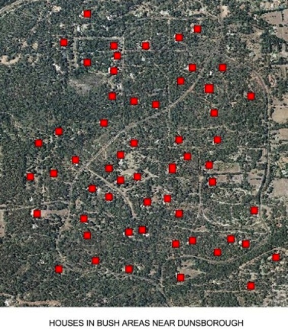
You can find dangerous situations like this all over the south west! Here’s another very serious one at Dunsborough.
Dangerous Road Design
The map below shows the location of houses near the popular holiday resort (and retirement centre) of Dunsborough, Western Australia. The red squares are the houses,marked on a recent aerial photograph. That the area is heavily forested is clear from the photograph. What is not apparent from the photograph is the heavy ground fuels in the area.
It is just this sort of situation where the houses, and householders, are at grave risk in the event of a wildfire under even moderately severe weather conditions. This was tragically demonstrated in Victoria in February 2009.
In addition, it can be seen that many houses are well off roads, and a fleeing householder will have to run the gauntlet of fire along narrow access tracks – a highly dangerous thing to do.
In situations like this, landholders must take the initiative to protect themselves, by arranging cooperative fuel reduction burning programs and carry out burns on a rotational basis over the whole area. Shire Councils and FESA have a duty to support such cooperative burning programs. There is no doubt whatever, that a properly organised and maintained fuel reduction program would provide good protection for householders in this area.
The design of some roads, having dead ends, is also a dangerous factor in a wildfire. In fleeing a fire in thick smoke it would be easy to become disoriented and turn the wrong way, towards the dead end, and so become trapped by the flames.