The WAIT Paper
The following paper is reproduced, with permission, from the proceedings of a symposium at the (then) WA Institute of Technology (now Curtin University) entitled “Fire Ecology and Management in Western Australian Ecosystems” (Julian Ford ed.). It is a comprehensive account of the practical experience of foresters in Western Australia that demonstrates the immense value of fuel reduction burning in mitigating the impact and facilitating the control of wildfires.
This paper has been updated and extended by Rick Sneeuwjagt with further material presented at the 5th International Wildland Fire Conference, Sun City, South Africa, 2011. The paper can be viewed here Rickpdf.
The Contribution of Prescribed Burning to Forest Fire Control in Western Australia: Case Studies
by Roger Underwood, Rick Sneeuwjagt and Gordon Styles
In: Symposium on “Fire Ecology and Management in Western Australian Ecosystems” J.R Ford, Ed, May 1985, Western Australian Institute of Technology. (Note: this article has been retyped to improve readability from the original two-column format, and also to remove a duplicated figure in the original).
Introduction
The major eucalypt and pine forests of Western Australia occupy only two million hectares and are restricted to the southwest corner of the State. Two factors influence management in this area. Firstly, the forests are managed for a wide range of protective, productive, recreational and conservation values (Beggs, 1982). Secondly, some 0.5million people live in or near the region. Each year this region experiences a hot, dry summer, during which wildfires regularly start in the forest (Peet, 1965, Luke & McArthur 1978).
For example, in the 30-year period 1954-1984, foresters dealt with 8533 fires burning in or threatening State forests (WAFD Annual Reports 1954-84). This represents an average of 284 fires each year.
Many of these fires occurred during severe or “blow-up” weather conditions (Burrow 1984). These conditions are characterised by high temperatures, dry fuels and hot, strong winds. Forest fires burning under such conditions can have catastrophic consequences: lives are lost and property is destroyed (Rodger 1961). They can also cause serious resource losses (Peet and Willimason 1968), erosion, siltation of streams, loss of wildlife and reduction of landscape values (Leitch et al 1983) and disruption to forest based industry, including beekeeping. Furthermore, the suppression of high intensity forest fires is highly dangerous and very costly. Nineteen firefighters lost their lives fighting forest fires in South Australia and Victoria in 1983. The direct firefighting costs of suppressing one fire n the karri forest of WA in 1969 exceeded $100,000 (Peet 1969), equivalent to nearly half a million of today’s dollars. This includes no allowance for loss and damage resulting from the fire, and for the value of volunteer firefighters working on adjoining farmland.
Foresters in Western Australia have been concerned about the problems of wildfire since the beginnings of forest management in the 1920s (Kessell 1923). Since then there has been a steady evolution in fire policy as research and field experience led to improvements in technology and to a better understanding of fire behaviour and its role in forest ecosystems (Underwood and Christensen 1981).
The current approach is based on the premise that since fire occurrence is inevitable, the aim must be to minimise undesirable consequences. Stemming from this philosophy two complementary management systems have emerged.
The first involves maintenance of an efficient fire detection system, backed up by effective firefighting forces stationed throughout the forest zone. This system has a proven capacity for rapid location and suppression of the fires, which break out under mild to average summer weather conditions.
The second system involves the systematic reduction of inflammable fuel on the forest floor by a programme of rotational prescribed burning. The aim of this programme is to help firefighters cope with fires starting under severe weather conditions or when many fires occur simultaneously. Under such circumstance the suppression task can rapidly exceed firefighting resources, leading to large, intense forest fires, and consequent social and economic damage. Current estimates show that the organisation required to suppress a large forest fire burning under severe conditions can cost up to $40,000 a day. Such a fire may take 5 or more days to be fully contained.
Experience over a wide range of weather conditions has shown that direst attack on forest headfires is not likely to succeed when flame heights are more than three metres or where fires are moving faster than 100 metres per hour. Fire behaviour is directly affected by the amount of fuel, and so long as inflammable fuel weights are maintained at less then about 8 tonnes per ha in the Jarrah (E.marginata) forests or about 15 tonnes per ha in the Karri (E.diversicolor) forests, there is a good chance that direct attack on the flanks of the fire will succeed with eventual control of the headfire by pincer action from the flanks. This applies even under severe weather conditions. Furthermore, areas of light fuel throughout the forest provide anchor points for suppression lines, refuge areas for threatened crews or civilians, and improved access for men and equipment working on a fire edge or suppressing spot fires ahead of the main front.
There have been no major fires since 1961 in the Jarrah forest, where a prescribed burning programme commenced in 1954, or since 19969 in the Karri forest where the fuel reduction policy became effective in the late 1960s (Underwood and Christensen 1981). During this time no single firefighter has been burnt to death in a forest fire in WA, – nor have there been any losses of life of civilians living in or near the forest zone. This contrasts with the “Ash Wednesday” fires in Victoria and South Australia in February 1983, which resulted in 70 deaths and hundreds of serious injuries.
Despite these results, both the effects and effectiveness of prescribed burning are challenged. For example, Raison et al (1983) suggest that a range of ecological problems may develop as a result of cyclic prescribed burning. They list alteration of ecosystem processes and components, accelerated soil erosion and depletion of nutrients. They also argue that since fuels re-accumulate after burning, the fire control advantages are short-lived and therefore dubious.
Though there is considerable literature on fire ecology, very little has been published on forest fire control in Australia on the contribution to control made by prescribed burning for fuel reduction, apart from Billings (1981) and Rawson (1983). However, there is a wealth of unpublished information and personal knowledge within the WAFD (WA Forests Dept).
Dating back over 50 years, records are available of nearly very fire which has occurred within State forests, together with detailed reports of investigations into serious and large fires. Departmental officers have also developed a reliable prediction system on forest fire behaviour and fuel accumulation for Jarrah, Karri and pine forests (Sneeuwjagt and Peet 1979), which can be used to make projections on the behaviour of past fires.
In this paper we present a selection of case studies drawn from this information. We attempt to illustrate the contribution of prescribed burning to forest fire control in WA and discuss the advantages and disadvantages involved.
Method
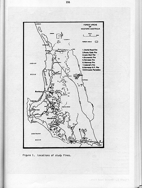
Forests Department records of forest fires in WA over the period 1969-1984 were consulted. From the numerous fires in which the beneficial effects of fuel reduction burning was evident, 9 were selected for detailed analysis (Table 1). In making the selection we tried to ensure that a range of forest and fuel types were represented, and that examples of major fire runs as well as smaller fires with high damage potential were included. The study has concentrated on fires occurring over the past 15 years to ensure comparability with current suppression methods. The locations of the study sites are shown in Figure 1.
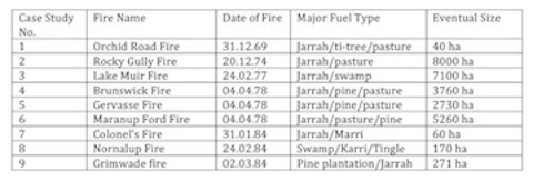
Table 1. The Study Fires
For each study fire we examined the fire report and record of each subsequent investigation, meteorological data from the nearest station, archive fuel type and fuel age maps and topographic and tenure plans. Fire behaviour projections were calculated using the WAFD forest fire behaviour table (Sneeuwjagt and Peet 1969).
These studies provided data on:
* Date and time of fire start.
* Cause of fire.
* Meteorological conditions leading up to, during and after the fire.
* Fuel ages and types.
* Actual and projected fire behaviour.
* Actual and projected fire size.
* Suppression measures.
* Values threatened.
Results: The Case Studies
1.The Orchid Road Fire of December 1969
The fire commenced in a farm paddock adjoining State forest at approximately 0930 hrs on 31 December 1969. It originated from smouldering logs within dry grass, fanned by strong easterly winds.
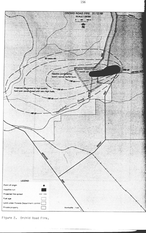
Weather conditions in the southwest had been severe for the previous three days, and a number of fires were already running in the region. The conditions at Pemberton Headquarters (15 km from the fire0 were 31°C temperature, 25% relative humidity and 45 km/hr winds with gusts to 60 km/hr. Under these conditions, predicted rate of spread in heavy karri fuels ahead of the fire was approximately 600 m/hr. In this situation, flame heights would have exceeded 20 m, and direct attack would have been impossible.
The fire expanded rapidly in the pasture and quickly entered State forest. It ran immediately into a narrow strip of forest which had been prescribed burnt in the previous month. Fire behaviour was mild and the edges were attacked directly by forestry crews when they arrived at about 1000 hrs. Including the area of pasture burnt in the farmer’s paddock, final fire size was 40 ha.
Suppression and mop-up was completed by 1430 hrs. The crews and machines were then transferred to another fire in the region.
The Projection: Beyond the narrow buffer within which the fire was contained, the forest carried 20 year old fuel loads. This area had been previously burnt by wildfire in 1950. The three major forest blocks in the path of the fire (Crowea, Dombakup and Warren) all comprised virgin karri, marri and jarrah forest. These blocks are surrounded by private property and National Park.
Easterly winds and high temperatures persisted for approximately 24 hours following suppression of the fire. This was followed by a southwesterly change. (Headfire rates of spread of up to 1000 m/hr were measured on another fire in similar fuels on the same day).
A projection of likely fire development over the first 5 hours of 31 December 1969 is shown in Figure 2. This projection assumes success in controlling the tail of the fire in private property, and that no long distance spotting occurred. It was estimated that the fire would have attained a size of 12,000 ha by midday of the following day (1 January 1970) and caused severe damage to forest and community values.
- The Rocky Gully Fire of December 1974
The fire commenced from burning waste at a sawmill located 7 km southeast of Rocky Gully. The time was 1230 hrs on 20 December 1974. On this day, temperature throughout the southwest exceeded 40°C and relative humidities were below 10%. Gale force northwesterly winds (60-70 km/hr, gusting to 90 km/hr) blew for most of the day until a southwesterly change came through in the evening. Departmental firefighters were simultaneously dealing with 44 separate fires in State forest that day.
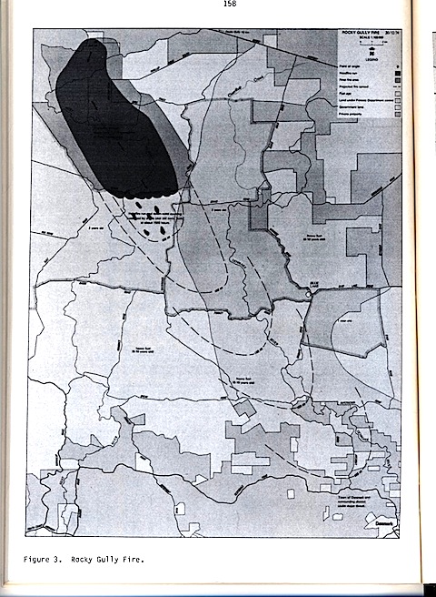
The fire escaped into vacant Crown Lands and was immediately attacked by sawmill workers, but they could not contain it. The fuels were open jarrah forest and open ti-tree flats, unburnt for at least 10 years (actual fuel age not known).
Fire behaviour was intense. At a rate of spread of approximately 6400 m/hr, the fire ran 15 km in 2.5 hours. Spotfires were numerous and developed up to 2000 metres ahead of the main front.
No Departmental firefighters were available to move to this fire due to commitments to other fires. In any case, fire intensity greatly exceeded that at which suppression could be attempted.
At 1500 hrs, the headfire and northeastern flank ran into forest prescribed burnt two and three years previously. The headfire stopped at this point. Control and mop-up was completed by a small team of volunteer bushfire brigade forces the following days. The actual fire size was 8,000 ha. See Figure 3.
The Projection: Assuming the headfire continued to spread at 6400 m/hr in the forest it is calculated that the fire would have run for a further 26 km and reached a size of approximately 30,000 ha over the period 1500 to 1900 hrs on 20 December. See Figure 3. Such a fire would have posed a direct threat to Denmark (population 1000) and surrounding farming communities.
- The Lake Muir fire of January 1977
Two fires were lit by an arsonist, in a Flora and Fauna Reserve adjoining State forest at 1710 hrs on 16 January 1977. Although fuels were estimated to be over 15 years old, conditions were cool and mild and firefighters successfully extinguished both fires the same evening.
Eight days later at 1315 hrs on 24 January, 1977, a new fire commenced in the same area, either an escape from one of the original fires or a third attempt by the incendiarist.
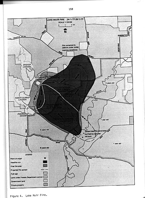
Conditions at the time were hot and dry (weather at Manjimup, 60 km from the fire, was 34°C, RH 24%) with northeast winds (20 km/hr) followed by northwesterlies in the afternoon. The fuels in the area were jarrah, paperbark and swamp, unburnt for at least 15 years.
Under these conditions, suppression attempts failed. Flame heights were recorded up to 8 m and the average headfire rate of spread was 1000 m/hr. Spotting was estimated at 200 m. Suppression efforts were deferred until evening under cooler conditions. Early the following morning, bulldozers succeeded in surrounding the fire with earth breaks.
The following day (25.1.79) was also hot and dry (temperature 37°C and RH 29%). Strong northwesterly winds up to 30 km/hr blew all morning followed by a southwesterly change in the early afternoon. Numerous spot fires occurred along the eastern edge of the fire; these eventually overcame the efforts of suppression crews. A major fire developed driven by the northwesterly wind. Headfire rate of spread reached 3000 m/hr. At 1400 hours the fire front ran into a one year old prescribed burn. The headfire stopped at this point. However, before this situation could be capitalised the wind swung from northwest to southwest and the whole northern flank of the fire broke away. A new fire developed with a 7 km front. Flame heights reached 35 m and the headfire rate of spread exceeded 6000 m/hr.
Late on the afternoon of 25 January the fire reached private property, comprising paddocks eaten bare by livestock over previous months and a network of firelines prepared that day. A heavy concentration of Departmental and volunteer forces was able to contain the fire at this point. All edges were contained on the following day. Final fire size was 7100 ha (see Fig 4)
The Projection: Had not the headfire driven by the northwest wind run into a one-year old burn, it is calculated that the southeasterly headfire run up to 1400 hr on the 25th would have proceeded a further 3.5 km before the southwesterly change came through. The subsequent breakout of the northern edge would have generated a fire size of approximately 10,000 ha and caused a more difficult suppression problem on private property and on State forest and Wildlife Reserves.
Cyclone Alby Fires of April 1978
On 4 April 1978, Cyclone Alby passed through the southwest corner of Western Australia. High temperatures, dry northwest winds of up to 140 km/hr, and a prolonged period of drought, combined to produce one of the most serious fire emergencies in the southwest forest zone since records have been kept.
Ninety-two separate wildfires developed within the region. These burnt out 54,000 ha of private forest, State forest and Crown Lands, but the area of State forest was confined to less than 7,000 ha. In all cases where fires entered State forest from neighbouring properties, they were contained or retarded by light fuels. The following three wildfire case studies provide examples of this.
- The Brunswick Fire
This fire occurred during the passage of Cyclone Alby on 4 April 1978. It started at 1440 hrs on private property from a spark from a rotary slasher. The fire ran 12 km in 1.5 hours indicating a headfire rate of spread of 8,000 m/hr. Fuels were mainly flats, jarrah forest and privately owned pine plantations. No suppression could be attempted on head or flank fires at any stage of the main fire run.
The fire burned through private property and skirted along light (4 month-old) fuels in the adjoining State forest on the eastern flank before burning through some 50 ha of the Forest Department Brunswick pine plantation. The head fire was then halted by light fuels within a large private forest block that had been burnt 5 months and one year earlier by the Forests Department in a mutual aid agreement with the owner.
Figure 5. Cyclone Alby Fires
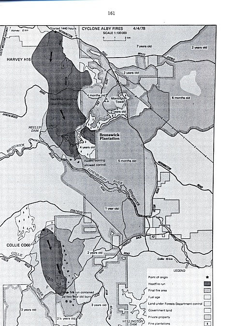
The fire was fully under control by evening and mopped up on the following day. The total fire area was 3,700 ha of which only 320 ha was in State forest.
- The Gervasse Fire
The fire commenced at about 1600 hrs on 4 April 1978. The cause is not known. Smoke and dust throughout the southwest obscured the fire detection system. It is probable that the fire commenced in grassland in private property as a spot fire thrown from the Brunswick fire burning directly to the north at that time.
No suppression activity could be attempted. Fire behaviour was not closely observed, but it appears that headfire rates of spread varied between 5,000 and 10,000 m/hr through privately owned bush and pine plantation. The fire entered State forest at approximately 1700 hrs driven before winds of over 100 km/hr. Fuels in the forest were only 1, 2 and 3 years old as a result of prescribed burning operations. The fire front was halted and contained in these areas. Numerous small spot fires occurred up to 3 km ahead of into these low fuel zones but failed to develop.
The tail of the fire was suppressed by farmers on the night of the 4th. No action was taken on the fire in State forest for another three days until firefighters could be freed from more pressing tasks elsewhere. During those days the fire trickled about in the light fuels, and burnt only 500 ha of State forest. It was eventually made safe by burning out to existing roads and firebreaks on 7 April (see Fig. 5).
The Projection of both the Brunswick and Gervasse fires: Northwesterly cyclonic winds continued unabated until 2300 hrs. At this time, a southwesterly change came through. The projection of these fires up to 2300 hrs if the fuels had been 10 years old, would show that both fires would have joined up and burnt out a total of 33,000 ha. This would have involved the total destruction of the Brunswick plantation, worth over a million dollars. More seriously, the spotting from a high intensity forest fire burning under cyclonic winds would have generated impossible conditions for firefighters and occupants on farms and townships downwind of the fire.
- The Maranup Ford Fire
The Maranup Ford fire escaped from a clearing burn on private property 16 km northeast of Bridgetown. The fire started at 1100 hrs and rapidly burnt through pasture and bracken fuels on steep slopes. The wind was northeast to north up to 40 km/hr. At about midday the fire was contained by bushfire brigade units at Huitson Road, in private property. However at about 1500 hrs the arrival of cyclone Alby winds of 80 to 120 km/hr caused the fire to break away to the south. The headfire reached rates of 5,000 to 10,000 m/hr. Spotting up to 10 km in front of the headfire occurred when the fire crossed the Blackwood River and accelerated up the southern slopes of the valley. Many of these spots eventually became part of the main headfire, whist others showed up as individual fires in State forest north of Manjimup townsite. The main fire eventually stretched 21 km, although 4 spot fires developed 3-6 km further downwind. During its run, the shape of the main fire was narrowed by the presence of 3 and 4 year old burns on the western flank. The headfire was effectively stopped on State forest when it reached a 2 year old burn. The spot fires which would have threatened the Manjimup community also failed to develop because of light fuels within a 5-month old burn located 15 km north of Manjimup.
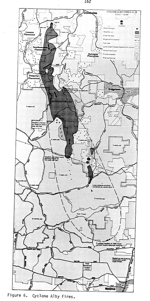
No suppression was possible during the main run of the fire because of intense fire behaviour, falling trees and flying debris.
Because of community problems elsewhere in the wake of the cyclone, suppression of the fire within State forest was given low priority, and delayed for 2 days. During these days, the fire trickled about harmlessly in light fuels. Final containment of the fire was not completed until 4 days later and involved the locating and mopping-up of many spotfires that had not developed in the light fuel areas.
The total fire area was 5280 ha. This included 270 ha of Forests Department pine plantation and 1,000 ha of native forest (see Fig 6).
The Projection: If the forest fuels ahead of the fire had been 10 years old, it is predicted that the fire would have reached the outskirts of Manjimup town by 1930 hrs. The cyclonic winds continued at Manjimup until midnight. In the absence of prescribed burnt fuel reduced zones in State forest, this fire could well have spread for another 30 km by 2400 hrs on 4 April covering an area of 40,000 ha of farmland and State forest. The town of Manjimup (population 3500) and settlements of Palgarup (130), Deanmill (200) and Jardee (100) may have been engulfed by this fire (see fig 6).
- The Colonel’s Fire of January 1984
The fire commenced at 1330 hrs on 31 January 1984 when a smouldering log from a clearing burn on private property flared up and ignited dry pasture. The conditions at the time were severe, with a temperature of 40°C and relative humidity of 16% recorded at Pemberton (20 km away). At the time of the escape winds were from the northwest at 25 km/hr. A strong (35km/hr) southwesterly wind followed at about 1400 hrs.
There was no one on the farm on the day and the fire was not immediately attacked. It entered thick scrub and burnt out into the neighbouring D’Entrecasteaux National Park. The forest type was mixed Jarrah and Marri and fuels were 10-year old (i.e. approximately 18 tonnes per hectare). Two Departmental firefighting crews were unsuccessful in attempts to control the headfire at this stage, and were withdrawn to work on the southeastern flank where fire intensity was less intense.
At approximately 1700 hrs the headfire ran into a one-month-old burn on state forest. The burn protected an extensive area of young Karri regrowth, pine plantation, state forest and National Park. The headfire was halted in the burn and suppression crews were able to contain the flanks by direct attack. Fire area was 60 ha (see Fig 7).
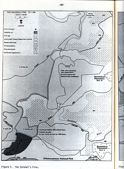
The Projection: Southwesterly winds, high temperatures and low humidity persisted for approximately 7 hours after the start of this fire. Given no protective fuel reduction burning in the area this fire would therefore have continued to spread at 400 m/hr fanned by the strong southwesterly wind. Such a fire had the potential to destroy large areas of highly valuable and fire sensitive Karri regrowth forest, pine plantation, National Park and private property.
- The Nornalup National Park Fire of January 1984
This fire commenced in National Park, presumably from a fisherman’s campfire at 0800 hrs on 24 February 1984. It immediately burned into an area of dense, impenetrable swamp where direct fire attack could not be mounted.
Conditions were mild, with weather readings at Walpole (4 km away) at the time being temperature 24°C, relative humidity 545 and winds northeast at 5-10 km/hr.
The fire was attended by a small firefighting force, who allowed it to burn slowly through the swampy country with the aim of tying it in later when it backburned out to access tracks.
At midday the wind veered to southeast and freshened to 25-30 km/hr. The flank fire became a headfire, reaching a rate of spread of 500 m/hr within the dense tree flats. At 1230 hrs the fire crossed the Southwest Highway and entered the dense mixed Karri and Red Tingle (E.jacksoni) forest in this are of National Park. These stands had not been burnt for 25 years.
At this stage the headfire rate of spread exceeded 300m/hr and direct attack failed. The headfire abruptly halted when it reached a one-month-old prescribed burn at 1400 hrs. This burn had been carried out to protect the Walpole townsite and adjoining farms. The flanks of the fire were contained by direct attack leaving a final fire size of 170 ha.
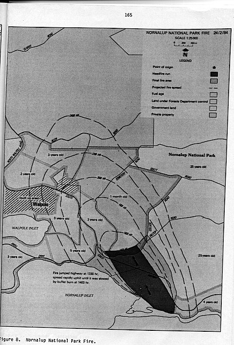
The Projection: Assuming a headfire rate of spread of 300 m/hr in the forest over a ten hour period from 1400 to 2400 hrs, eventual fire size could have amounted to 900 ha from this fire. Apart from National Park, this area is likely to have included the eastern part of the Walpole township (population 800) and the surrounding farming community. Strong northeasterly winds occurred on the following day which would have driven any running fire into Walpole township, emphasising the value of containing this fire to a small size (see Fig. 8).
- The Grimwade Plantation Fire of March 1984
The fire commenced at 1420 hrs on 2 March 1984 in 50-year-old Pinus radiata plantation at Grimwade. The cause of the fire was not established.
Conditions were hot (35°C) and dry (relative humidity 20%). When the first forces arrived, the fire was influenced by light northeasterly winds. Suppression was difficult due to the intensity of the fire and difficulties of access caused by logging debris. Before the fire could be contained a strong (35 km/hr) southwest wind change at 1730 hrs caused the fire to break away and expand rapidly. The rate of spread of the fire varied from 700 to 1000 m/hr, augmented by continuous spot fire development 200-500 m in advance of the headfire. Flame heights exceeded 30 m, and a crown fire developed.
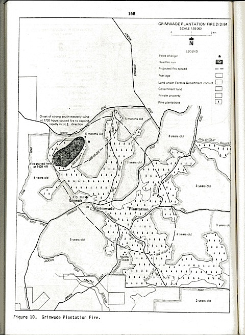
At 1930 hrs the headfire burnt out of the pine plantation and entered a strip of Jarrah forest separating the burning pine form another plantation 1.5 km away.
The Jarrah stand had been prescribed burnt 5 months previously. This burnt area was part of a system of buffers around the Grimwade pine plantation that had been systematically burnt every 4-5 years as protection against wildfires. Once it entered this buffer, the headfire decreased in intensity and was successfully suppressed. This was followed by direct and successful attack on the flank fires still burning within the plantation.
The final fire size was 171 ha, including 18 ha of Jarrah forest. Approximately $400,000 worth of pine trees were killed in the fire.
The Projection: High temperatures and strong winds persisted up to 2100 hrs. Allowing for a headfire rate of spread of 700 m/hr in the pine forest and of 400m/hr in the adjoining jarrah forest (assuming 10 year old fuel), a fire of 500 ha was estimated for the period up to 2100 hr. By this time, the fire would have burnt an additional 80 ha of mature pine plantation and about 250 ha of high quality jarrah pole forest. As strong northwesterly winds were experienced on the following day, the rest of the Grimwade plantation (2,300 ha) and the Grimwade settlement (population 100) and sawmill could also have been under major threat as indicated in Figure 10 (Figure 9 was a duplicate of this figure).
Discussion
The presence of zones in the forest where fuels had been reduced by prescribed burning was an important factor in reducing fire size and improving the ease of control in the cases studied. The projections indicate that in every case a larger fire would have led to serious social and economic costs to the community.
Any theoretical projection of a fire can be debated. This is because the development of a forest fire is influenced by two sets of factors. The first are physical and environmental, i.e., weather, fuel and topography. These factors can be measured and their effects on fire rate of spread calculated with reasonable accuracy. The second set of factors are the suppression forces brought to bear on the fire perimeter by the firefighting agency. Firefighter effectiveness is highly variable: it is influenced by fire size and intensity, access, terrain and forest type, the equipment used and numbers of men and machines available. All these factors can be roughly predicted, but not so the intangibles such as leadership, morale, fitness and organisation.
In the fires studied in this exercise, we tried to project the “most likely” result, based on known physical factors, knowledge of events prevailing at the time and our own firefighting experience. (The combined firefighting experience of the authors in the jarrah and karri forests exceeds 70 years.)
The small sample of case studies does not, of course, present a statistical or scientific support “for” the contribution of prescribed burning, in the sense that plot or laboratory studies on soil nutrients before and after fire are sometimes cited as proofs “against” (Raison et al 1984).
Nevertheless, in the context of a record of no serious forest fires over more than two decades and the accumulated summer experiences of hundreds of Western Australian forest firefighters, it is difficult not to acknowledge the positive contribution to forest fire control which the prescribed burning policy has made.
This view is further supported by comparative data on fire size between the southwest and other areas with similar climate, terrain and forest type, but where no prescribed burning program is in place. For example, Mount (1984) has presented data, which indicate that the average fire size in comparable forests in Tasmania is 18 times larger than in WA. The figure for Victoria is approximately 12 times and NSW 13 times (WAFD 1980).
The case against prescribed burning is usually based on two factors: ecological damage and dubious fire control benefit (Considine 1984). The first question is contentious (Attiwill 1985); certainly not enough research has been done yet to fully elucidate the effects of the range of possible regimes (including fire exclusion) on the range of forest ecosystems in Southwestern Australia.
In our opinion, the question of fire control value is not contentious. Light fuels resulting from prescribed burning do reduce fire intensities and improve the ease of fire control. Of course fuels do re-accumulate. Therefore, there is a need for a cyclic programme of fuel reduction, where burns are repeated once a critical level of re-accumulation has been reached. In the southwest forests this critical level takes about 5-8 years in Jarrah and Karri forests and 8-10 years in forests further east adjoining the main agricultural zone. In an 8-year rotational burning programme approximately 50% of forest fuels will be 4 years “old” or younger, providing excellent opportunities for wildfire control under difficult conditions.
Finally, five important points must be made.
- A prescribed burning programme should not be embarked upon without solid data on fuel accumulation rates and fire behaviour. This is needed to allow rotation lengths to be tailored to site characteristics and vegetation factors, and to enable prediction of fire intensity on the day. Without these data, fires may be lit too frequently or too rarely, or may be difficult to control and lead to the sort of suppression costs and damages the burning programme is designed to minimise.
Research into fuel accumulation and fire behaviour in WA forests is probably further advanced than for any other WA vegetation type, but is still incomplete and continuing.
- A prescribed burning programme is not a fire control system by itself It must be welded to an effective detection and suppression organisation.
Fuel reduction does not prevent forest fires. In fact, numerically most forest fires start under relatively mild conditions and are easily suppressed by a quick moving and well trained firefighting force.
- Managers asked to implement a prescribed burning programme must be thoroughly trained, possess a high level of technical expertise in fire behaviour and control and be provided with men, equipment and finance to implement the policy. The complicated and diverse the prescriptions, the more costly they will be. This demands a high level of agency commitment, and Treasury support.
- To be successful and effective, a prescribed burning programme must be thoroughly planned at three separate levels of implementation. First, there needs to be a regional burning plan which indicates the most suitable burn boundary location, burn frequency (rotation), season of burning for each forest area and highlights areas which are not to be burnt both regionally and within daily “jobs”. Such a plan should be reviewed and updated each year for the following 5 year period.
Secondly, burning prescriptions must be prepared months in advance. These involve detailed inspection and fuel sampling, and indicate the most suitable weather conditions and ignition procedures required to meet burn objectives. In preparation for the burn such tasks as perimeter track maintenance and notifications to neighbours and forest users must be planned.
Finally, on the day of the burn, the wide range of tasks involved with the ignition and containment of the fire must be planned in detail and well coordinated. To be effective, burns should cover at least 60% of the area; patchy, light burns will not provide useful fuel reduction. All burns must be thoroughly mopped up and subsequently patrolled to ensure the edges are safe.
- A prescribed burning policy, like any system of forest ecosystem management, must be accompanied by an active research programme. This should be focused on fire regime effects (including the study of unburnt controls) and on the development of improved fire detection and suppression systems, so that any change in one part of the fire management approach can allow a calculated adjustment to be made somewhere else. Research into social factors and community attitudes is also needed (Underwood 1985).
The current fire management policy in WA forests is not regarded as an end-point. Adjustments are continually being made in the light of changing community attitudes and improved science and technology stemming from research and management experience. In the meantime, the current policy, which included the regular, cyclic burning of about 70% of the southwestern forests (excluding areas set aside for scientific study or specific species conservation programmes), provides a high level of community security from the ravages of intense fire, improved safety for firefighters and an opportunity to develop and test a range of alternative fire management systems.
References
Abbott, I, & O. Lonergan. (1983). Influence of fire on growth rate, mortality and butt damage in Mediterranean forest of Western Australia. For. Ecol. Manag. 6:139-153.
Attiwill, P.M.(1984). Effects of fire on forest ecosystems. In: Research for Forest Management, CSIRO (in press).
Beggs, B.J. (1982). General Working Plan for State Forest in Western Australia. Working Plan No. 87, Part 1. Forests Dept West. Aust.
Billings, P. (1981). The Effectiveness of Fuel Reduction Burning. Five Case Histories. Fire Research Branch Report Div. Forest Protection, Forests Commission, Victoria.
Burrows, N.D. (1984). Predicting blow-up fires in the jarrah forest. Forests Dept West. Aust. Tech Paper 12.
Considine, M.L. (1984). Prescribed burning and forest nutrition. Ecos 42:9-12
Forests Dept West. Aust. (1980). Submission to Grants Commission.
Kessell, S. L. (1923). Paper presented to a conference of senior officers of the Forests Dept West Aust. Perth July 1923. (unpublished).
Leitch, C.J.,D.W.Flynn & R.H. van de Graaf. (1983). Erosion and nutrient loss resulting from Ash Wednesday (16 February 1983) wildfires: a cost study. Aust Forestry 46: 173-180.
Luke, R.H.& A. G. McArthur. (1978). Bushfires in Australia. Forestry and Timber Bureau Div. Forest Res., CSIRO, Canberra.
Mount, A.B.. (1983). The case for fuel management in dry forests. Paper to Research Working Group No 6 on Fire Research, Hobart 1983.
Peet, G.B. (1965). A fire danger rating and controlled burning guide for the northern jarrah (E.marginata Sm) forest of Western Australia. Bull (74), Forests Dept. West. Aust.
Peet, G.B. (1969). The Boorara fire 7th to 12th March 1969. Internal Report Forests Dept West. Aust.
Peet, G.B. & A. J. Williamson. (1968). An assessment of damage for the Dwellingup fire in Western Australia. Papers to IFA Conference, Perth, 1968.
Raison, R.J., P.V.Woods & P.K.Khanna. (1983). Fuel dynamics in recurrently burnt eucalypt forest. Paper to 10th Triennial Conference of Instit. Foresters Australia, Melbourne, 1983.
Rawson, R. (1983). Effects of fuel reduction burning on wildfire behaviour. In: Fighting Fire with Fire. Symposium on fuel reduction burning in forests, 17-18 September 1983. Monash Uni., Melbourne.
Rodger, G.J. (1961). Report of the Royal Commission appointed to enquire into and report on the bushfires of December 1960 and January, February and March 1961, in western Australia.
Sneeuwjagt, R.J., & G.B.Peet. (1979). Forest Fire Behaviour Tables for Western Australia. Forests Dept. West. Aust.
Underwood, R. J., & P.E.S.Christensen. (1981). Forest Fire Management in Western Australia. Special Focus (1). Forests Dept. West. Aust.
Underwood, R.J. (1984). Research for fire operations in Australia. In: Research for Forest Management, CSIRO (in press).