The January 2018 Sawyers Valley bushfire occurred under moderate temperature but windy conditions. Believed to have been started by an arsonist, the fire started at about 8 AM alongside Gorrie Road and moved rapidly to the west-south-west in jarrah and wandoo forest, driven by gusty easterly winds into fuels that varied from 7 to 20 years old. These fuels were much heavier than they should have been, due to lack of fuel reduction burning in past years. In the northern jarrah forest zone any area with fuels older than 5 year will sustain a crown fire.
The fire was lit within a forest quarantine zone, which is supposed to be closed to the public in order to enable forest managers to map the occurrence of dieback disease and prevent new infections being initiated by unrestricted public access. Clearly, those access restrictions are not being enforced adequately or the arsonist could not have entered.
The weather was being influenced at the time by a rain bearing cloud mass from decaying tropical cyclone Joyce heading south. This had generated the strong easterly winds on the day. In the event, the rain from Joyce arrived too late to assist in controlling the fire, but it did damp down the whole area after the fire was contained.
The rate of spread of the headfire was more then 500 metres/hour so a headfire attack was impossible. Instead Parks and Wildlife (PAW) suppression efforts were directed to pinching out the flank fires with bulldozers, with mopping up the burning edge being carried out by field crews behind the dozers. Several waterbombers were also employed, including the Ericksen Skycrane, but they contributed little to the suppression effort.
In one instance, however, a surveillance helicopter carried out an amazing rescue of a trail walker who had camped at a hut on the Bibbulmun Trail. He was surrounded by the fire and was in great danger. A fortunate break in the smoke enabled the chopper to locate the man, whose presence was unknown to the firefighters. A small clearing near the hut allowed the chopper to land and pick up the walker and take him to safety.
The bush around the hut was completely burnt out and the hut itself was also burnt, the ruins being demolished by a wandoo tree burning down on top of it.

Huge volumes of smoke were generated by the fire, sending a pall over the metropolitan area. From nearby Mundaring the smoke column appeared very close, although the town was never in any danger.
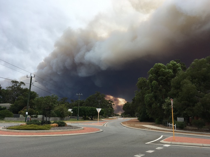
The smoke from Mundaring
The rapid fire movement, hilly terrain, and the heavy fuels in its path also generated intense development of spot fires ahead of the main fire front, making the work of firefighters more difficult and more dangerous.
The fire was controlled late in the day when it ran into light fuels that effectively stopped it altogether. The total area burnt was about 4000 ha and included valuable pine plantations that were in the process of being harvested. Nearly all the pine trees were killed. Unfortunately, some tree harvesting machinery, valued at $1.6 million, was also destroyed.
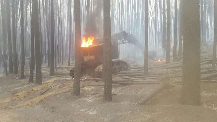
The mechanical tree harvester still burning
The course of the fire is shown in the map below, starting from the eastern (right hand) end.
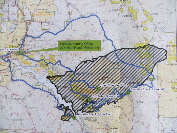
The map gives the false impression that the Mundaring Weir stopped the fire, as it was 200-300 metres in width where the fire hit it. Actually, it did not. The fire was steaming along at 500m/hr throwing spot fires over a kilometre ahead, so the spots easily jumped the Weir. They fell into a large area of two year old fuel on the south west side of the Weir and either went out or just trickled around and were easily suppressed by the ground crews. You can see on the map that only a small area of forest was burnt across the Weir.
The fire map also demonstrates the need for fuel reduction burns to be large, at least 3km in depth, to be able to contain the spot fires resulting from a fast moving headfire.
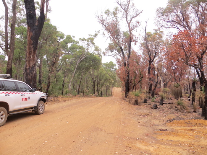
This was not the only example of low fuel levels assisting the firefighters on this occasion. The southern flank also ran into two year old fuels and required little or no suppression effort, just a few minor hopovers.
The photo below shows an area along the southern flank of the fire with the burn area on the right and the two year old fuel on the left. A conclusive demonstration of the value of fuel reduction burning!
On a larger scale, this effect is shown in the following shot, which shows a broad area of forest completely defoliated by a crown fire, but the green forest canopy at the top of the shot is where the two year old fuel in the previous shot has stopped the fire.

Much of the burn area was covered by a crown fire, resulting in complete defoliation of the trees, as shown below.
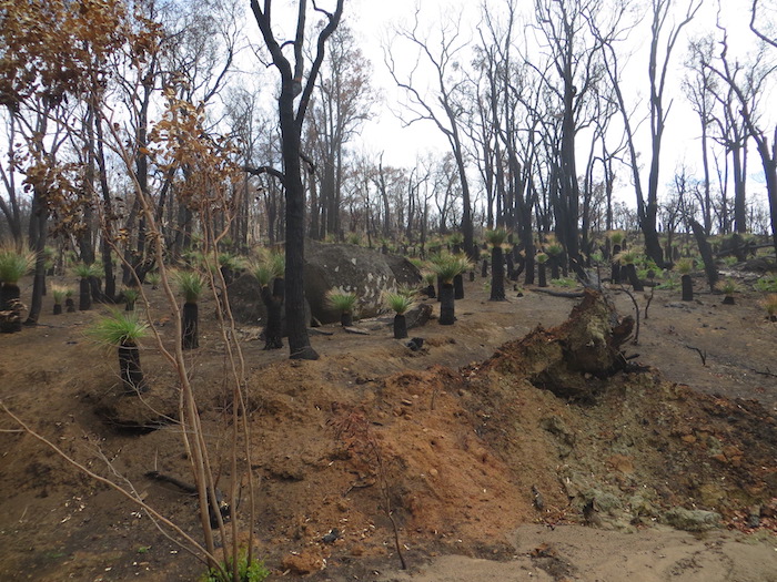
While most of the jarrah and marri trees will recover from the fire, a large number will have been killed. A large number of trees with hollow butts also burnt down. The wandoo is much more fire sensitive and large numbers will have been killed outright, thus altering the extent of forest cover in this area. Since maintenance of the forest cover in the region is essential to prevent movement of subsoil salt into the streams, this may have long term effects on water quality in the dam.
There were virtually no unburnt patches left, so the soil was bared over nearly all the burn area. A day or so after the fire was controlled, ex-cyclone Joyce arrived, and about 100mm of rain fell in the area, causing extensive soil erosion in the burnt area. Since the fire was located very close to the Mundaring Weir (see map above), water purity in the dam will be adversely affected, not just from this rainfall event, but from early winter rains as well.
The arsonist must have scouted the fuels in the area carefully before deciding where to light up, as they selected the “dirtiest” patch they could find. The result was to maximise the damage caused to the forest and the catchment.
PAW has made good progress recently in reducing the backlog of fuel reduction burning in the region and it is unfortunate that this bushfire took place where it did.
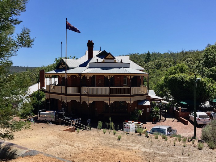
What might have happened. At one stage there was concern that the fire would impact the historic Mundaring Weir Hotel, if the wind direction had veered to the south east, as it often does.